If this is your first visit, be sure to
check out the FAQ by clicking the
link above. You may have to register
before you can post: click the register link above to proceed. To start viewing messages,
select the forum that you want to visit from the selection below.
I wasnt aware of this. Interesting assessments, most are based off of old data than actual on the ground work.
Ive been out there a bit and never saw any tunnels. Thats an interesting tidbit that makes me want to head out and look again. I know they already destroyed the buildings but tunnels would still be there...
I have some pics somewhere of the tunnel and what it looks like now. It is filled in and just has a pipe and a manhole where the entrance used to be. Water is still pouring out of it too.
How big is the pipe? The water doesn't look that deep. Could you possibly walk up this tunnel to one of the mines? I have never been out there but am interested in going exploring in that area.
How big is the pipe? The water doesn't look that deep. Could you possibly walk up this tunnel to one of the mines? I have never been out there but am interested in going exploring in that area.
According to information in the book "Mining, Smelting, and Railroading in Tooele County", the tunnel from Bauer into the "combined mines" was lined with timbers due to being in loose material (NOT hard-rock), so it's a fairly sure bet that once the mining was shut down and the tunnel abandoned that it's caved in. In fact, if you know what you're looking for, you can pretty much tell that the tunnel has caved when you look at the area on Google Earth.
I'd say I'm fat and out of shape, but, "round" is a shape...
What are the coordinates on google earth for the tunnel?
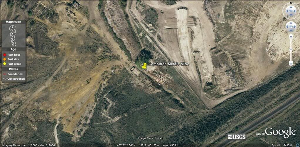
Here's the view of the area in Google Earth:
To the left of the marker, you'll see a foundation/outline for a building. This was the old change house that was at the entrance to the tunnel, and you can see, extending downward and to the right the indentation of the collapsed tunnel.
I'd say I'm fat and out of shape, but, "round" is a shape...
Ah the Bauer tunnel, a legend that has intrigued many! I do believe that it has got to be in the absolute worst of condition. I doubt even a rat could use it to get under any of the Stockton mines.
Now off topic:
I want Google Earth with earthquake tracking!
Ah the Bauer tunnel, a legend that has intrigued many! I do believe that it has got to be in the absolute worst of condition. I doubt even a rat could use it to get under any of the Stockton mines.
Now off topic:
I want Google Earth with earthquake tracking!
Here's the link to the Google Earth page that has the plug-in (or whatever it's called) for real-time earthquake tracking:
P.S. Don't drink the water! I remember reading in the above mentioned book that it's tainted with Arsenic and is non-potable. However, it was pretty good to growing apple trees though. It's quite a tragedy the tunnel is likely caved in since it did access a lot of good workings.
 Tweet
Tweet


Comment